Another procedure that is enabling aircraft to improve efficiency and reduce emissions is called ‘free route airspace’. Traditionally, aircraft have flown along fixed routes, like motorways in the sky. Free route airspace allows aircraft to plan more efficient, direct routes with stable trajectories, saving time and fuel and therefore reducing emissions. This procedure requires cooperation among the countries which an aircraft flies over, and is being applied successfully in Europe.
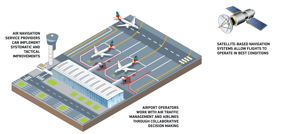
The engagement and cooperation of governments and international institutions is critical if the potential of new navigational technology is to be realised. Airspace is governed by sovereign states, meaning that any reform needs governmental buy-in. But aviation transcends national boundaries, therefore airspace should be organised and air navigation services delivered in line with operational requirements, rather than national borders. This would mean that airspace would be controlled across multiple countries.
The greater harmonisation of airspace allows aircraft to navigate seamlessly across national borders on the most efficient routes. In some regions, such as the Middle East, large areas of airspace are reserved for the military, meaning civil aircraft must fly around these areas, adding time, fuel burn and emissions.
The Civil Air Navigation Services Organisation (CANSO) is working with governments in those regions to free up this airspace when not required for military purposes to allow for more direct commercial routes.
In Europe, a collaborative project is underway called the Single European Sky ATM Research (SESAR). It is part of the vision to transform Europe’s aviation infrastructure, enabling it to handle future growth while minimising environmental impact with efficient flight routes and optimised trajectories.
Once in place, the Single European Sky will be a key enabler for enhancing sustainability, contributing to an effective environmental improvement of the sector and helping to be more resilient.
The SESAR programme was initially launched in 2008 and the third phase runs until 2031. SESAR aims to contribute to CO2 reduction by reducing fuel burn by between 250-500 kilograms per flight between 2012 and 2035, a relative improvement of 5-10% – this corresponds to between 800-1,600 kilograms of CO2 emissions per flight.
The second phase of the programme delivered 127 solutions that could be deployed in the system to reduce emissions from air transport – in total, an estimated 4% reduction in CO2 emissions per flight could be achieved with the solutions delivered so far.
A similar modernisation of airspace is underway in the United States. Once fully implemented, the Next Generation Air Transportation System (NextGen), like SESAR, will result in significant emissions reductions.
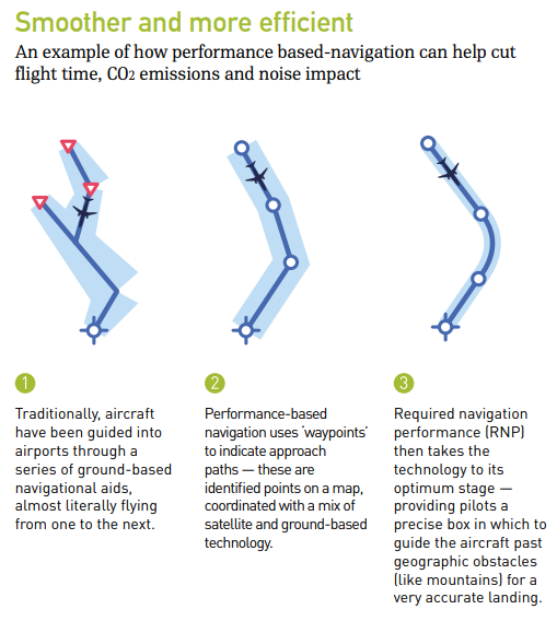
The NextGen project is being undertaken by the US Federal Aviation Administration (FAA) and aims to simplify US ATM by rolling out Performance Based Navigation (PBN), an advanced satellite-enabled form of air navigation, and other satellite-based technologies known as Automatic Dependent Surveillance-Broadcast (ADS-B) that replace radar technology, as well as collaborative air traffic management technologies.
Reacting to changing weather conditions is another way flights can become more efficient. In the US, a new NASA weather software programme is helping US airlines improve efficiency by allowing flexible routing. It allows pilots to react to changing weather conditions and alter their routes accordingly, rather than simply following a predetermined flight path.